The entire eastern seaboard of New South Wales and Queensland had been experiencing constant flooding rain for weeks on end and the damage to property and lives has been incalculable.
We left Sydney on the 9th March during a lull in the rain, but it was still very windy as we made our way south along the Princes Hwy until we got to the Picton Rd and then onto the M1 motorway, or Hume Hwy as it is known. Stopped for lunch at Gundagai and then Holbrook to fill up on fuel. The highway now bypasses this tidy town, which is a shame as it used to be the place to stop for a break and some lunch, back in the old days.
I had decided to stop at a rest area for the night, just south of Benalla, but after spending an hour there, soon decided us to pack up and tow the van back to the Benalla showgrounds, which had grass and was away from the traffic sounds and big trucks pulling up for toilet breaks and rests, always leaving the engines and compressors running.
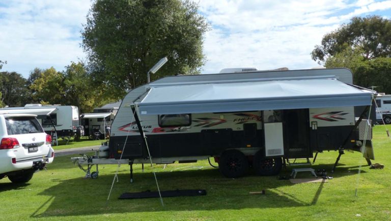
Day 2 saw us heading towards Bendigo, where Beryl wanted to stop and have a look at the woollen mill. I had run out of propane gas in one of the gas bottles, the day before and found a place to get it filled, as well as a nearby service station to fill the car. It turned out to be a very tight fit with the van on, but having entered the street, I couldn’t back out again, as the traffic was heavy. Anyway, a few back up and turns just allowed the van to squeeze past the bowser and the bollards. Narrow streets, traffic, roundabouts and a 20ft caravan are not a match made in heaven.
We were going to stop at Maryborough for lunch, but the GPS took us down back streets and we ended up missing the entire township. Stopped at Avoca, where the café was still serving. Asked for a couple of pies, which she got out of the refrigerator, saying that they were still hot, as she had just put them in there – they weren’t hot but it was the only place in town that we could find.
The countryside was very picturesque with green farmland and great hills. Passed through a town with the biblical name of Ararat, which was quite pretty and saw a big sign, promoting their big gaol, built especially for the criminally insane. We didn’t stop.
We continued on our way to the overnight stop at Wannon Falls, arriving there around 4pm.
We parked under the shady eucalypt at Wannon Falls rest area.
The Wannon Falls are a punchbowl waterfall located in the Southern Grampians Shire, approximately 19 kilometres west of Hamilton, in western Victoria, Australia. The falls are fed by the Wannon River that has its head waters in the Grampians mountains. There is a 30-metre vertical drop of hardened basalt lava into a deep plunge pool at this waterfall.
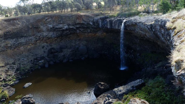
The falls didn’t have much water flowing, but spectacular never the less.
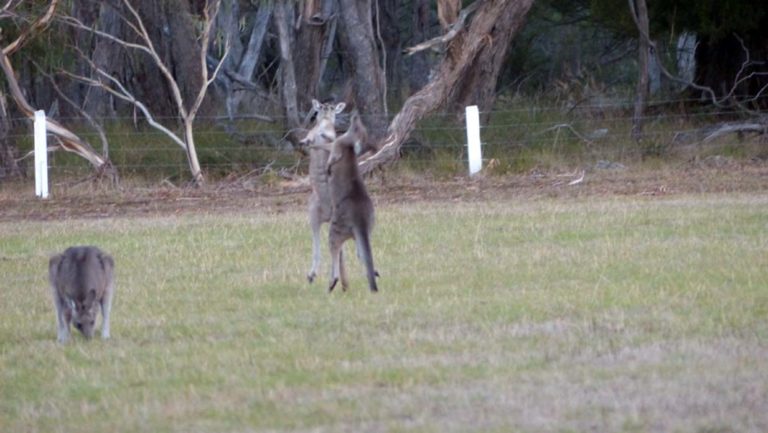
Despite all the rain we had on the east coast, it didn’t really get this far south west, so the falls weren’t flowing too strongly. A nice relaxing stop over though, with the added bonus of young kangaroos testing out their sparring skills on the paddock beside the caravan.
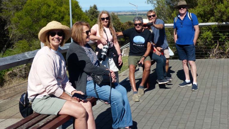
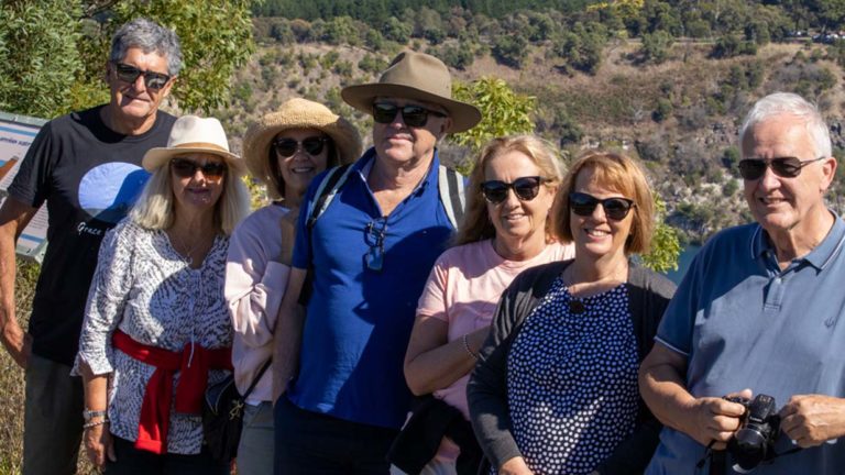
The following morning, we had a leisurely run to our next stop, the Pine Country Caravan Park in Mt Gambier where we were going to meet up with the rest of our contingent, who had left a few days earlier than we did and spent time at Ardlethan and Wentworth. They arrived later that afternoon and we set up for a BBQ dinner together, where everyone relaxed in the very fresh evening air (actually very cold and crisp) and then hopped into bed.
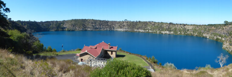
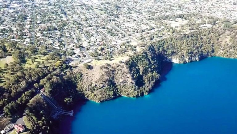
Day three started with a chorus of corellas which woke us all and got us up relatively early. The Blue Lake was less than 5 minutes away so we drove there and parked to do the 3.6km walk around its circumference.
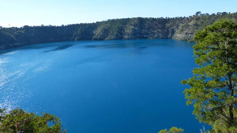
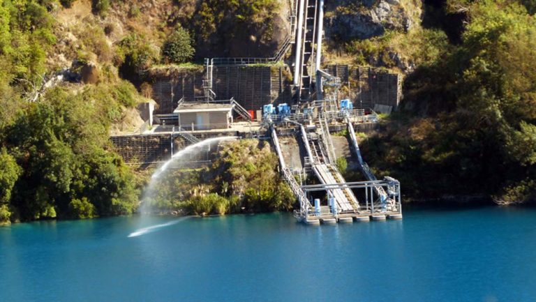
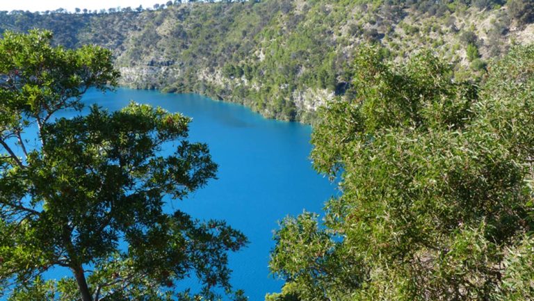
The Blue Lake is a volcanic crater and is one of the youngest volcanoes in Australia. It is an explosive structure called a maar which consists of a rim of ejected basalt and ash resting directly on the land surface. The Blue Lake is used as Mt Gambier’s water supply and the water quality is very good. It is replenished by infiltration of local rainfall and stormwater together with lateral groundwater flow, through the limestone aquifer.
The lake is flat bottomed with an average depth of 70m. During December to March, the lake turns to a vibrant cobalt blue colour, returning to a colder steel grey colour for April to November. The exact cause of this phenomenon is still a matter of conjecture, but likely it involves the warming of the surface layers of the lake during the summer to around 20 °C, causing calcium carbonate to precipitate out of the solution and enabling microcrystallites of calcium carbonate to form. This results in scatter of the blue wavelengths of sunlight. The view of the lake was spectacular and the surrounding countryside was beautiful. Mt Gambier was clearly visible in the backdrop.
Our next stop was Umpherston Sinkhole which was located in the town of Mt Gambier as well. The gardens and park are a remnant of a late 19th century garden developed by James Umpherston with the sinkhole as a feature. The sinkhole was once a typical limestone cave that formed by the corrosion of limestone rocks by seawater waves and the sinkhole was naturally created when the chamber’s roof collapsed.
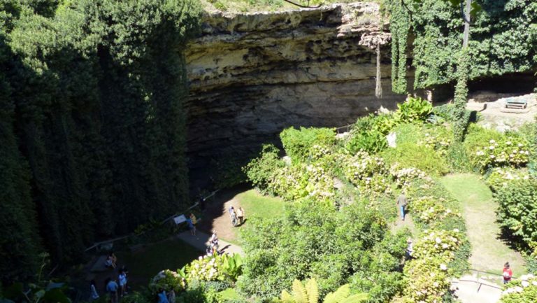
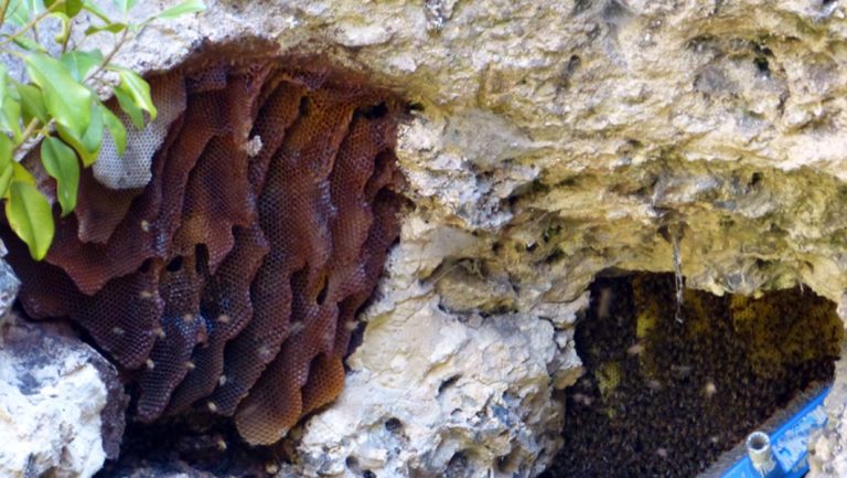
The gardens in the sinkhole had some interesting features with huge hanging curtains of ivy – and beehives formed in the holes in the limestone.
We continued on and went to the small cave garden in the centre of town which was fairly unremarkable and overgrown. Across the road was a café – Sorrentos – where we had lunch.
Trev, Clare and I went back briefly to the Blue Lake where Trev put up the drone for a few aerial shots – only a brief fly as the batteries were half empty – enough to get some shots and a nervous fly back to home.
We sat around enjoying happy hour but as soon as the sun went down it was so cold we escaped inside to the comfort of the vans.
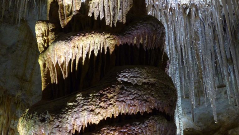
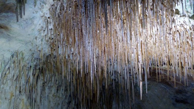
Had a leisurely start the next morning, leaving the campsite for a 22 min drive to the Tantanoola Cave, our first stop for the day. The cave had been discovered in the 1930’s by the son of a local farmer on whose land it was. He had been chasing rabbits with his ferret which went down what he thought was a rabbit hole but did not return. The teenager threw a couple of rocks inside and heard loud noises – he then crawled in and discovered the amazing cave below. The family started charging for cave tours about 2 weeks after that!
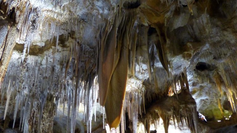
National Parks bought the area later on and have cared for it to ensure it is well preserved. We entered the cave and it was a beautiful cave, with the most formations packed into the one cave. Spectacular! The tour lasted 30 mins.
Once back outside we did the short cliff walk above the cave which gave us a great panoramic view of the local area. The cave guide had told me that the pine forests around the area were owned by Kimberley Clark – and used for making toilet paper (a COVID lockdown essential!!) No shortage around here.
We then drove on for 40 mins past Penola back to the Coonawarra wine area to a winery recommended to us by the caravan park owner – Brand’s Laira Winery.
It was a beautiful winery with the oldest vines in the district planted in 1893 by Captain Henry Stentiford the first owner of the vineyard. Eric Brand took over the vineyard in 1952.
The grounds were well kept and manicured with beautiful rose gardens among the vines.
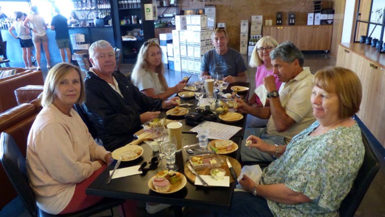
We entered into the cellar door area and enjoyed a fantastic Ploughman’s lunch and wine tasting. Kerry and Dave were in their element!