Sunday 14th August – Day 22
Aurukun was 207 kms by the map, and we were going to drop in and see a couple of friends, Anne and Neil Ewart, who we hadn’t seen in many years. Neil had told us it would take about 2 ½ hrs to get there.
We got to the turnoff to Aurukun after 97-odd kms, and turned right. It was another 207 kms into town. The road was very good until about 35kms out and it got a bit bumpy. Neil said this was due to the last rains they had that made a bit of a mess.
After a quick cup of tea, Neil gave us the royal tour of town, which included the new airstrip, the barge landing, the old and new houses, the council chambers, the shop, the police/courthouse complex and the box which the army use when they do manouevres in the area.
Must be great fishing in such a remote part of Australia
It took us about 20 mins and then we were back at the house. We set up camp in the front yard and then put dinner on. It was a bit of an eye opener, that all the non indigenous homes had high wire fences and padlocked gates around the perimeter.
Neil said that a security patrol drives around at night to ensure the padlocks were on and everyone was locked in for the night.
Hmmmm – not a place I want to live in. We had to keep travelling so said our goodbyes in readiness for our exit in the morning
Monday 15th August – Day 23
Our objective was Musgrave Roadhouse, which is at the intersection of the main road, and the road out to Lakefield NP. We had stopped and had lunch there on the way up, but had not stayed there. We didn’t want to stay somewhere we had already stayed.
It meant a fairly long drive, but as we had left pretty early, and the roads were pretty good, we expected to get there in plenty of time.
All was good then and we made it to Musgrave about 4:30pm, after having an early lunch at Archer River roadhouse.
The facilities were a bit ordinary, so I don’t think we will put this place on our list of ‘must do again’ places. I am sure we will survive the night and be ready to head off in the morning to Lakefield NP.
Wednesday 10th August – Day 18
Packed up in a mist filled morning. First mist we have had since home.
Oh, oh. Where do we go now.
We took off and arrived in Weipa without any issues. The ‘cruiser bounced around a bit on the one rear shock and a couple of times it bounced me across the road. Had to be very aware of oncoming traffic, of which there was very little. As soon as we arrived in Weipa we went to the repair place that we were told about and they said they could do it in the afternoon. We set up camp in a nice shady spot and sat down to relax.
Campsite at the Weipa caravan park
We took the car up and eventually got it fixed, despite them initially trying to install front shocks on the rear! We had lunch at the local café, but we won’t be going back. We found out Weipa has the dearest Woolies in all of Australia! We still shopped there, as had no choice. A quiet night was had by all.
Thursday 11th August – Day 19
We booked up for the Rio Tinto bauxite mine tour at 2:30. The tour bus picked us up at the campsite at 2:30 and found out we were not allowed to leave the bus due to OH&S reasons.
Bauxite stains everything red
The tour was ok, and we got to see the digging and filling of the bauxite and then the sending to the filter, sizer, and onto the train for shipment to the shipping dock in Weipa. The tour went for 2 hours, but I don’t think it was worth the $30 each we paid.
Mark and I went to the beach at sunset to witness a most spectacular spectacle. With the fires around the place the sky was amazing.
Took some nice shots with a person throwing a cast nest in the foreground, and also one of an Egret fishing for food.
Friday 12th August – Day 20
Today we decided to go up to Mapoon and Cullen Point to try some fishing and the girls could sit and relax near the beach. It was about 90km north. Originally we had planned to stay there for 4 days, but because of the issues with sand flies and mites, we decided we would only go up for the day. That turned out to be a very good decision, as it was a dump! It would be ok for a couple of blokes going for fishing only, but there was no shade, and absolutely nothing to do except fish. With the low tide we witnessed, even fishing didn’t look appealing to us. We turned around and went straight home.
Between Weipa and Marpoon is the bridge over the Mission River. This bridge is a single lane bridge which is just over 1 km long. It is also a train bridge for the ore to be taken to Weipa from the mines. An interesting fact about the rails on this bridge is that there are no joins in the rails. This is to eliminate a failure in any joins.
There are also two inside rails which connect to two wheels on the carriages to ensure no sideways movements in the carriages and a possible de-rail situation. If an ore train went off this bridge, it would be a very big incident indeed.
I wanted to try my new cast net, so we went down the beach about 4pm and got a few mullet and lots of glass-eye fish.
Saturday 13th August – Day 21
Today was planned to be a quiet one, and that is the way it panned out. Mark and I went for a fish about 7am. We must have caught 60 bream, but only 12 were of legal size. We were there until about 10:30 and then we had to scale and clean them.
We will be heading out tomorrow for Aurukun, hopefully early! It’s a bit hard to get some people up.
Tuesday 9th August – Day 17
We had decided to only stay the one night at Elliot, so today we headed out early to drive the vast distance of 7 kms, to Fruit Bat Falls. We had heard from so many people that these falls were the best for swimming and picnicking. We arrived there pretty quickly, but only after negotiating a long crossing with water up to the top of the bull bar. It was a muddied water crossing as another car had just gone through heading in our direction.
We got out of our cars with great anticipation. It was about 10:30am so it was warm enough for a swim. The falls were about 70m wide and dropped about 3m in a curtain.
Giant Pitcher Plants – an insect eating carnivorous species
After lunch we got back on the ‘highway’ and headed to the spot where we had lunch on the way up, and we were successful in finding the knob to Marks cooker, which we lost nearly 2 weeks ago!
We continued onto our final destination for the day of Moreton Telegraph Station, on the Wenlock River. We set up camp on a grassy patch away from everyone and also started the generator for power.
Spawn eggs of the filthy cane toad
The Wenlock was very picturesque. Dinner was the flathead and trevally we had caught at Vrilya and it was very nice.
Monday 8th August – Day 16
Everyone up early today as we had to try to beat the tide on the beach, else we had to drive on the soft stuff. After packing up, we headed down the beach, leaving a beautiful spot. We reached the southern end of the beach without incident, even though we had to travel most of the way on the soft stuff.
Coming back off the beach
Stopping at the end of the beach, we pumped our tyres up again – only to about 33psi – and headed back along the bumpy track towards the log bridge. Coming in from the western end was a bit different from the other way, but we both got across ok, even though Marks left trailer wheel fell into the gap between two logs, and slid sideways until it hit the end of the logs.
Back on the ‘highway’, we turned south and then turned off again on a short bit of road that joined the new with the old. It was on this road that we had the next bit of fun, which was Sam’s crossing.
With it’s crystal clear water, it was very enticing, but we were told by people who we had just met, that we had to keep to the left, as the right was deep. Mark did that and was surprised how much a car can lean over without toppling over, especially considering the weight he had on the roof!
Where did that hole come fromCrystal Creek Crossing
With that challenge met, we turned back south on the Old Track and headed towards Elliot Falls camp ground. With ½ km to go, we came across the Crystal Creek crossing. There were two entrance paths and we took the easier one. The other one looked certain to drop the left wheel off a rock shelf, into a large hole about thigh deep. Our path was pretty straight forward, although straight it wasn’t! It was all curves, but still quite easy.
Out of that one, and we hit the Elliot Falls turn about 11am and into the grounds we went. We had heard that the spaces were limited and we were a bit concerned, but on the way in – about a 1 km drive, six vehicles were departing so we then knew there would be some camp spots. We drove around and found them quite easily, although to get a single site we could all fit on, took us until the 4th last camp site.
All the sites were built by NP people, so they had green pole bollards up and you could only park where the vehicles could fit. We were lucky enough to find a big one without any real restriction. So we set to getting organised and had camp set up very quickly. We had a quick bite of lunch, and then headed down to the falls. In this location, there was Elliot Falls, Twin Falls, and Indian Head Falls. Elliot Falls was a horseshoe shaped fall on the Elliot Creek, while the other ones were the typical cascading falls of another creek that joined Elliot Creek below it’s falls.
The falls were beautiful and we spent a couple of hours swimming and sitting in natural pools.
It was really nice to cool down in the water, but we were all a bit ‘prunie’ so headed back for sausages and vegies, and eventually bed. We were all tired.
Thursday 4th August – Day 13
Today we packed up our gear at Seisia, and headed down to the Jardine River for an overnight stay and to do a spot of fishing. We didn’t end up leaving Seisia until about 12:30. The Jardine was only 45kms away so there wasn’t a real hurry. We were not sure what we would find at the Jardine River. There are 3 free camp areas, and one council (aboriginal) run affair. We had heard bad reports about the council one, so we looked at the site on the northern side of the river to see what it was like. It was beautiful and we ended up having it to ourselves.
Campsite along the banks of the Jardine river
We setup tents, then put the boat in, looking cautiosly for crocodiles as we walked through the shallow waters, heading to deeper waters to start the engine. It was a large river with a fast flow. We topped up the fuel tanks, rigged up a rod, and Marg joined us for another few runs up and down the river, trolling for some fish.
Nothing happening, so we finally headed back to the sandy shore, and had to be satisfied with a garlic lobster feast of painted crayfish tails that had been bought on TI yesterday. Delicious. We also had a bit a rain while we ate, so it was very refreshing, and cooled the night down.
Friday 5th August – Day 14
We decided to stay a second night at this spot. It is really restful. After lunch,we went fishing again in the boat. We went downstream for about 4 klms. We trolled and flicked as we went down, and again on the way back. I hooked a Saratoga, which leapt through the air, but got off. A bit later I flicked along some lily pads and got a hit and landed a jungle perch. About 4 or 5 all jumped out at the lure, but a second and third pass yielded no more hits. We saw two Palm Cockatoo’s today. Apparently they are quite rare to see, and they have the most unique call. Nothing at all like the Sulphur Crested one. It was really melodic.
We had talked earlier about crocs and we decided that there were none in the area, only to find out that while we were sitting in the tent, and shining a light out across the river, we saw the tell-tale red eyes of a croc sitting on the far side at water level. We watched him for a while, until he submerged (or closed his eyes). When we saw him again, he was sitting in the middle of the river on the shallow sandbank. We watched him for a while again, and when he disappeared and re-appeared, he was back on the other side. We then gave up watching.
Saturday 6th August – Day 15
Two weeks have passed already. We wanted to find the old Jardine crossing, so went for a drive in the direction it should have been. We went down a few tracks and finally came across it. I really don’t know people managed to get across there. Either it has dramatically changed, or people were dramatically stupid! From the bit we saw on the north side, it hasn’t been used for quite a while as it was all over grown, and lily pads covered the water-side of the crossing. It also looked about 3m deep. We could see the far side and looked a lot easier. It also looked about 100m away! Saw a big saltie in the lilies right at the ‘crossing’.
When we got back, it was time to start packing up. We had to head back to the ferry crossing (only about 14kms away), where we had to get fuel. Of course, as soon as we got off the ferry, there was then a big queue for fuel, at $2.20 per litre! It was still cheaper than Seisia which was $2.36 !! My fuel bill was $374 to fill my tanks.
From the crossing we headed back down the ‘highway’ for 26.5 kms where we took the unmarked road to Vrilya Point. This a 27 km track that went back to the west coast of the cape. Four klms in, we had to cross the infamous log bridge.
Mark surveying the bridge for any tricky bits
This is a bridge made up of logs across a 2m gully. The bridge was about 10m long. The approach and departure parts of the track were severely rough. You had to pick your path even getting to the bridge, then pick which logs to drive on, and then you had to pick your path out the other side.
At Vrylia, we decided to head up the beach. We had not let our tyres down (deliberately), and we drove as far as the lightship wreck and stopped for photos.
oopsCampsite on the beachJacky lizard blends into his background
It was here that we let the tyre pressures down. We got to the end of the sand and turned right up into the Casuarina trees that would provide shelter for out tents.
Wednesday 3rd August – Day 12 Today we headed off to Thursday Island. As usual, it was a blowy day, but this one seemed even more so.
Traditional fishing at Thursday Island
Heading over to TI was not too bad, but we knew coming home, into the wind was going to be something else. We had a good look around the shops, and around the harbour, and at 3:30 we had a bus tour of the island, including a tour of Green Hill fort.
This was quite interesting. The day ended with a not-too-rough ride home on the boat.
Arriving back into Seisia, we witnessed a lovely sunset.
Sunday 31st July – Day 9
First thing on the schedule next day, was to head over to the office to try to move to a better site. We managed to get one close to the water but were still in the wind, but not as bad as yesterday. All was good, and we have a beautiful view of the water from our kitchen area.
After a cuppa, we decided that we would go to Punsand Bay for lunch and sample their ‘famous’ fish and chips.
Lunch at Punsand Bay
After lunch, we headed through a really beautiful, single lane, track through the bush – including quite a few tricky bits and came out on the track that heads to the most northerly point on the Australian mainland.
It was about a 20 minute walk from the car park to the ‘tip’ and it was really beautiful. It was also really windy.
Made it
It was well worth the walk, and lots of photos were taken.
Monday 1st August – Day 10
This was a quiet day for us all. Basically we chilled out at the camp. Mark and I went fishing off the jetty and I caught a Golden Trevally. Very pretty fish, but not the big ones we were expecting.
Had to jostle for a spot at the Seisia jetty
Nice Queenfish
Tuesday 2nd August – Day 11
We went for a drive out to a Beaufort Bomber wreck, which crashed near the current airport during WWII.
Remains of the Beaufort Bomber
Dc3 in the jungle
There was also a wreck of a DC3 which came down in 1945. In the predawn darkness while circling to land at Higgins Field (Bamaga), crashed into a hilltop at 5:18am and burned on impact, killing everyone aboard. Initially, the military authorities thought that there may have been a third American passenger who boarded the aircraft at Townsville, but this was later found to be incorrect.
After leaving the planes, I noticed a noise in the rear of the car. Upon investigation, we discovered a broken shock absorber. The left rear shock had come out of it’s fitting at the top, and was just sitting inside part of the chassis. We tried to remove the fitting, without success. After talking to the mechanic, and a couple of other people, we decided to head on as per normal without it.
Friday 29th July – Day 7 We were only going 50 or so kms to the first stop which was an aboriginal art area. It was only 300m from the car park, but it had to be the longest 300m in the world! Back on the dirt and the road was in very good condition. We sat on about 90kms and the distance slipped by pretty quickly. Next stop along the way was Musgrave for lunch. Coen was originally our final destination but at lunch we discussed going past Coen and onto Archer River roadhouse/campsite.
Set up at Archer River
We finally pulled into Archer River about 4pm, after 362 kms.
Saturday 30th July – Day 8
From Archer River, the next stop was at the Morton Old Telegraph station and then Bramwell Junction for fuel.
This was also the start of the Old Telegraph track. We weren’t going down that road, as we were doing the southern bypass, but we did go and see the start of the track at Palm Creek crossing. It had been chewed out by over enthusiastic drivers and was a bit of a ruin. Heading north at the crossing was doable, but going south was a real challenge.
When we got out for a look, there was a young couple down at the creek surveying as to whether or not to attempt the southerly climb out. After a bit of discussion, they elected to turn back and go around the long way (25kms).
We were just about to get back in our cars when 4 more vehicles came down to see what it was like. They wanted to do it -well, the men wanted to do it.
The first vehicle went down the wrong line and made a bit of a mess, but the other 3 did it easily. The northern bank was easier and they all climbed out ok.
Our next ‘obstacle’ was the Jardine River crossing. It is made a lot easier nowadays, because there is a ferry! It is easier, but not cheaper – $99 for car and camper, and $88 for car only. It is return fare included however.
From the Jardine crossing, it is only 45kms to Bamaga so we were on the home run.
We pulled into Bamaga about 4pm, and a day earlier than planned. That is because we were able to do the ‘dirt’ road in 2 days, rather than the 3 we had allowed for.
We booked in to the Seisia caravan park for the night.
First night in exposed site
Wow, did it blow during the night and we were set up in a very open spot, so copped it. Mark and Wendy were ok in their camper, but Margaret had her tent and we also had ours. Marg had a tent pole snap during one gust and it tore a hole in the tent and fly.
Tuesday 26th July – Day 4
Up early again this morning as we had a fair way to go. Left the camp at about 8:15 and turned towards the north again. Emerald was the first port of call, with an aim of McDonalds for coffee. There weren’t too many exciting things on the road as it was basically going through unimproved country most of the way. We arrived late afternoon, at the caravan park at Belyando Crossing, which was our overnight stop.
Wednesday 27th July – Day 5
At Belyando Crossing we were all lined up in a row so that as many vehicles as possible could be squeezed in. Too bad if you were in the middle and wanted to get out early!
Bit squeezy
This place is quite remote and about 13 hrs drive north from Carnarvon Gorge, so was really the only place to stay overnight unless we could find a freecamp somewhere, which wasn’t successful. Had a chuckle in the cafe, as we were waiting for a coffee and some food. A well to do couple pulled up in a mercedes and the woman ordered a cappuccino and the guy wanted a latte. The young girl serving, looked a bit perplexed and went around to the food prep area, where I saw her spoon International Roast coffee powder into two mugs and bring them out to the couple. I had to leave before I burst out laughing.
We headed off north again, and the trip was pretty well the same as the previous day. The road was very hilly and with a strong headwind, the ‘cruiser was down to 2nd gear in places. Feels wrong to have to accelerate going downhill, into the teeth of the wind. We ended up staying at a large grassy area, next to a creek, 12 kms west of Ravenshoe. There were already about 15 vans there but we got in ok. It was a clear night and the stars were magnificent.
Next morning we met the rooster of Ravenshoe along with his harem. We thanked him for letting us stay the night, before heading off again.
Thursday 28th July – Day 6
Well today was supposed to be a short one – only 273kms. Anyway, we headed into Mareeba via Ravenshoe and Atherton. Every road seemed to go uphill, with some seriously steep bits.
The country was very up and down, with beautiful vistas and we finally came to the caravan’s final camp site – Lakeland Caravan Park, at the start of the dirt.
Tomorrow we head onto the corrugations and bull dust – that will be interesting.
We woke up to -1 degrees . It was a tad cold. After a breakfast of toast and cereal, we packed up and were on the road about 8:15. First stop was McDonald’s in Goondiwindi for coffee and loo. From there it was onto St George for lunch, then Surat, Roma (fuel), then Injune and finally to Carnarvon Gorge. It was a long day, as it was further than we thought. It ended up being 705 klms.
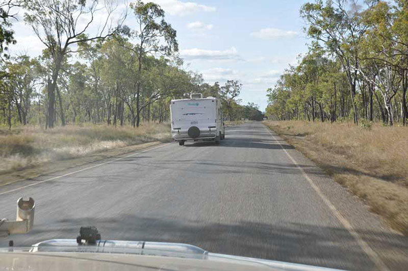
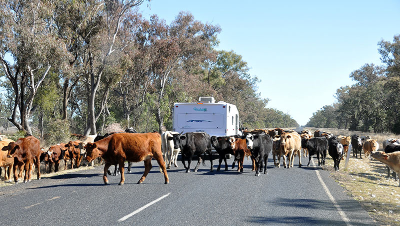
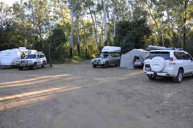
Long Road heading off to Carnarvon GorgeCattle rule the roadTakaraka Bush Camp, Carnarvon Gorge
We arrived at Carnarvon gorge at 7pm and set up in the dark.
Monday 25th July – Day 3
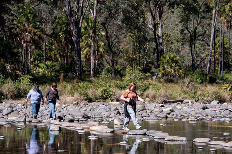
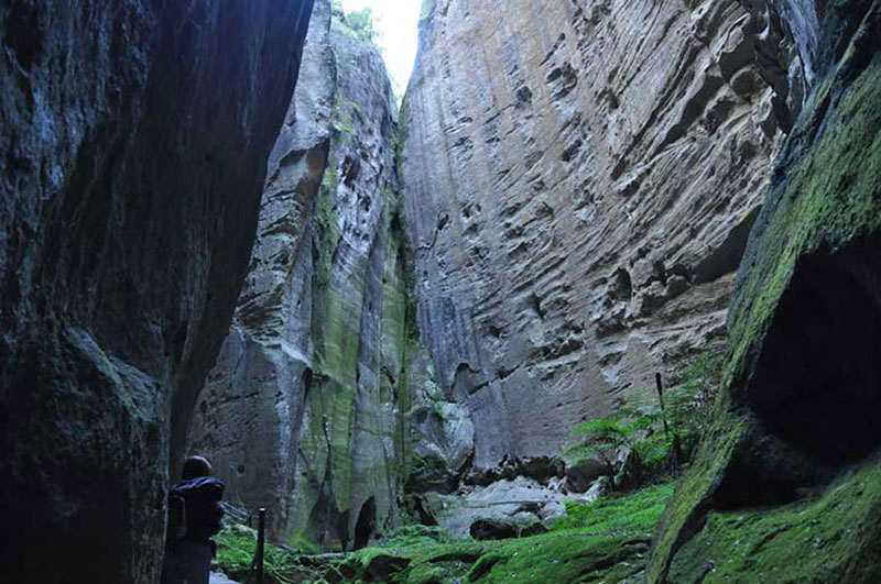
Today, we were heading into the gorge to see which walks we could do, within a reasonable time frame. We checked out the maps and decided to do Moss Garden, the Amphitheatre, and the Art Gallery. Mark and I would probably also do the Ward’s Canyon walk.
Heading off into the gorgeAmphitheatre
It was a long day – 7 hours elapsed – but we saw some really nice things. We are all feeling a bit stiff and sore, and I am sure tomorrow will bring a few other aches.